

Planetary has released an Environmental Baseline Survey report to document the environmental conditions in and around St Ives Bay, particularly the marine environment surrounding the wastewater diffusers off Godrevy Head. This report, prepared in support of the proposed ocean alkalinity enhancement carbon removal trial, contributes to our scientific understanding of the local marine environment, and provides a snapshot of data to contextualise future monitoring work.
The full report, prepared by Planetary’s technical team with the support of Plymouth Marine Laboratory Applications, is now available.
See Full Report
Summary
The baseline data collected in May 2023 indicate a typical marine environment for the region. As predicted by hydrodynamic modelling of the area, the water column is well-mixed, the water chemistry is broadly aligned with historical data collected from St Ives Bay and Cornish waters, and the flora and fauna communities are typical of the area. There is some evidence of increased metals loading in the environment, particularly in marine sediments, but few metals reach or exceed international guideline values designed to safeguard ecosystems. The observed elevated metals align with the existing understanding of legacy mining runoff and historical trace metal loading in the area.
While further baseline data collection will likely be necessary in order to understand the potential impacts of a long-term or large-scale OAE project in the area, this survey, combined with other data, suggests that the region would not be particularly sensitive to a scientific pilot project of limited scale.
Report Background
Collecting high-quality baseline data is an important component of a responsible field trial. A thorough understanding of the local marine environment helps guide scientific projects, informing initial project designs and enabling project developers to identify trends or changes in the marine environment that may be linked to the project’s operations.
This baseline report contributes to Planetary’s knowledge of the current physical, chemical, biological, and geological characteristics of St Ives Bay. It is part of our efforts to conduct due diligence research to understand the marine system before proposing any long-term scientific or ocean alkalinity enhancement project in the area.
This survey was conducted without any accompanying addition of alkalinity in order to observe the natural conditions of the site.
This baseline survey primarily aimed to:
- Establish a set of representative monitoring sites for repeat sampling in future surveys, particularly if Planetary continues with its proposed Ocean Alkalinity Enhancement (OAE) project in Cornwall
- Develop and share a high-quality set of baseline data for the area in springtime, including data on the physical, chemical, and biological characteristics of the water column and on sediments, fauna, and benthic habitats in the area
Field data for this report was collected in May 2023 at four sites in and around St Ives Bay, primarily through dive surveys, sediment sampling, and seawater quality sampling . Field data was supplemented with historical data, literature reviews, and ocean modelling studies.
The May survey was the second major field data collection Planetary has undertaken in the area, following a separate survey in September 2022 that focused on the potential to detect an OAE signal in St Ives Bay.
Together with other forms of research, including ecotoxicology research on five locally occurring species conducted in lab settings and an independent assessment conducted by Water Research Centre (WRc) the two baseline surveys form part of Planetary’s ongoing commitment to ocean safety in the context of our proposed trial in Cornwall.
Results
Identification of Survey Sites
Planetary identified four suitable survey sites in and around St Ives Bay, including one site at the wastewater diffuser, two sites in the diffuser’s “mixing zone,” and one control site.
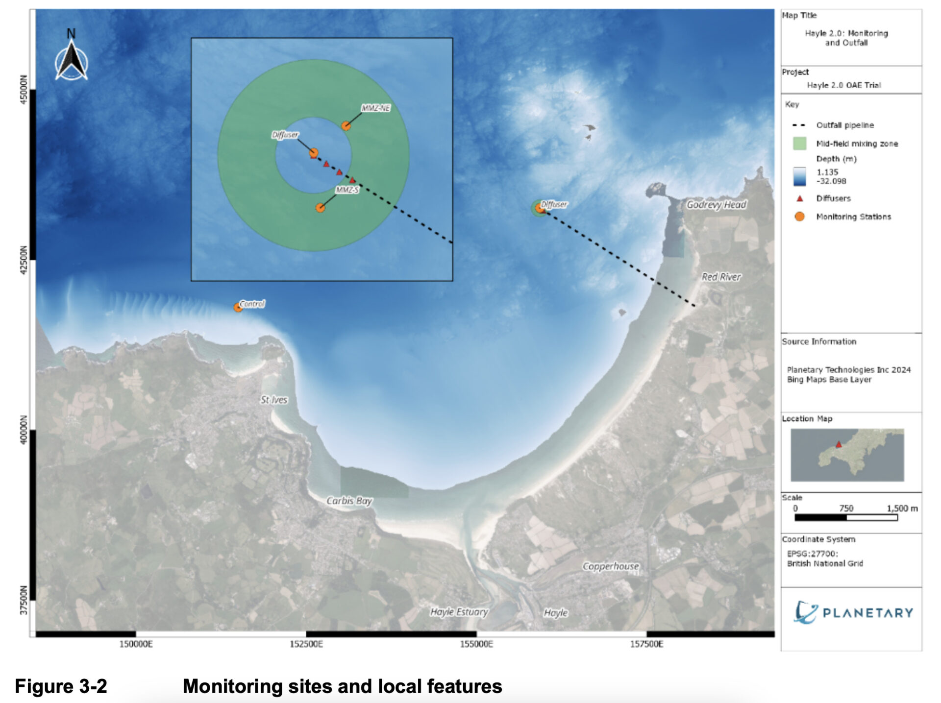
Ocean modelling initiated in 2021 indicated that the mixing zone, where effluent reaches the ocean surface and dilutes with the receiving waters, extended to between 50 and 125 metres from the outfall. Multiple regulatory standards governing efflu
ent discharge require sampling or monitoring within the mixing zone, so two survey sites were placed in this area. The two sites were each placed 60 metres from the diffuser, to the northeast and the south. Of these two sites, data from this study suggest that the southern site m
ay be better placed to identify wastewater effluent signals.
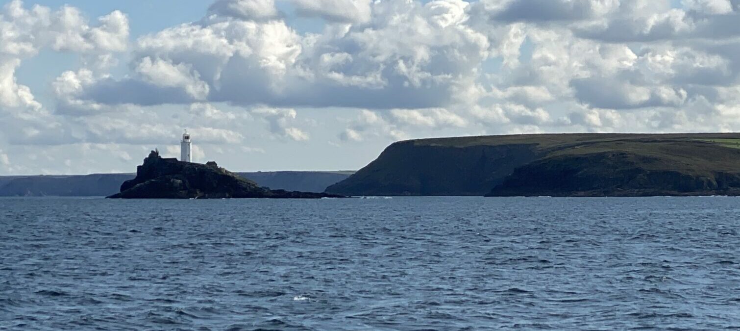
The control site was selected among other candidates based on its distance from the diffuser, its similarity (in both benthic habitat and water column characteristics) to the diffuser site, and its distance from any sensitive local receptors that could be disrupted by monitoring activities. The selected control site sits approximately 5 km west of the diffuser, off Porthmeor Beach.
Planetary also identified the L4 buoy near Plymouth, operated by Plymouth Marine Laboratory, as a source of potentially useful contextual data.
General Water Quality
The seawater column in St Ives showed typical characteristics for coastal UK waters in springtime. They align well with readings from Buoy L4.
The water column was well-mixed, with little variation in salinity, pH, dissolved oxygen content, or turbidity by depth. The surface waters were found to be slightly warmer than deeper waters.
There was some spatial variation for pH and salinity readings between sites, with the freshwater perhaps affecting readings in the southern mixing zone. Total Suspended Solids (TSS) readings varied between sites, as well as between triplicate samples, indicating a need for continued repeat sampling in future studies.
Trace Metals in Seawater
Significant attention was given to analysis of trace metals loading in the bay, both in the water column and in sediments. St Ives Bay has a history of mining contamination, particularly concentrated around the Red River and Hayle Estuary, and Planetary sought to identify which metals, if any, approached hazardous levels in the ecosystem.
Water column samples were analysed for a total of 18 trace metals, each of which was compared to a number of international standards and safety thresholds, including those of the United Kingdom, the United States, the Netherlands, Canada, Australia, and New Zealand. Standards were included for both acute and long-term metals levels.
Most water column samples showed that no metals exceeded any legislative standards or safety recommendations. However, samples at three locations (the diffuser, the control, and the northeast site in the mixing zone) indicated elevated levels of total mercury which exceeded one long-term water quality standard. Mercury levels were therefore identified as an area for ongoing monitoring.
Metals loading in seawater did not appear to be higher overall at the diffuser than at the control site, suggesting elevated background levels in the area, rather than point source contamination.
Sediment Metals
Elevated levels of metals in the water column can settle on the seafloor and accumulate in sediments. To gain insight into the sediment metals loading, Planetary collected sediment samples at three of four survey sites.
As with water column samples, sediment samples were analysed for 18 metals and compared to several international standards.
Most metals levels remained within all international standards at all sites. However, samples taken from the diffuser and southern mixing zone sites indicated that zinc levels slightly exceeded one of nine comparison thresholds. Zinc levels were, however, lower at the control site, suggesting that proximity to either the diffuser or to historical contamination sources contributed to slightly elevated zinc levels.
Metals in Invertebrate Tissues
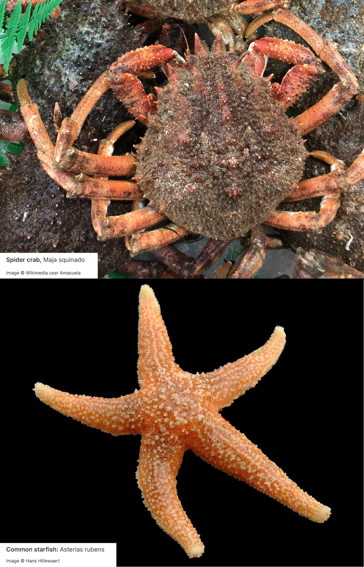
Tests were also conducted to identify any elevated metals content in the tissues of local invertebrates. These tests evaluated specimens of a crustacean species (the spider crab) and an echinoderm (the common starfish) taken from three of four sites.
Fewer standards are available to evaluate safe levels of metals in organisms than in sediments or the water column. Furthermore, natural levels can vary significantly based on species and taxonomic group, and available standards from the UN and the Oslo and Paris Commission (OSPAR) indicate safe levels for metals in fish and bivalves rather than crustaceans or echinoderms. To supplement these imperfect comparisons, our specimens were also compared to baseline data from a 2015-2017 study of similar taxonomic groups in Scottish waters. Most samples aligned well with the Scottish data.
Of the 18 metals evaluated, 14 were either not detected in marine tissues or were only detected at levels below all comparison thresholds. Arsenic, copper, and zinc were detected in one or more specimens above UN or OSPAR standards for fish and shellfish, but below Scottish contextual data. Across all samples, only chromium exceeded any of the levels of the Scottish data, in one specimen from the diffuser site. This specimen was anomalous, and was identified as a data point requiring additional verification.
Continued monitoring of metals content throughout the ecosystem – water, sediments, and tissue – will be particularly important if alkalinity additions proceed in the long term in the area, as alkaline feedstocks may contain trace levels of metals that will be released into the marine system alongside the primary mineral. To avoid this, Planetary performs elemental analyses on each batch of minerals under consideration for use in its OAE projects, and rejects feedstocks with high levels of trace metals before they are ever shipped to project sites. Planetary also commits itself to ongoing ecosystem monitoring of trace metals at its project sites before, during, and after a trial to identify any changes in metals content that may be attributable to the project’s operations.
Plankton
 Communities of phytoplankton and zooplankton were analysed using samples collected from the surface and from a depth of 10 metres, respectively. They were analysed by an independent specialist lab for diversity and abundance per taxonomic group.
Among smaller plankton, communities were dominated by diatoms, a simple type of algae that follows “bloom and bust” growth patterns. Also observed were several types of dinoflagellates, ciliates, and silicoflagellates. While St Ives has limited historical plankton data available, this data aligns with many temperate systems, including data from nearby Station L4 that indicates a diatom-dominated spring bloom in the spring.
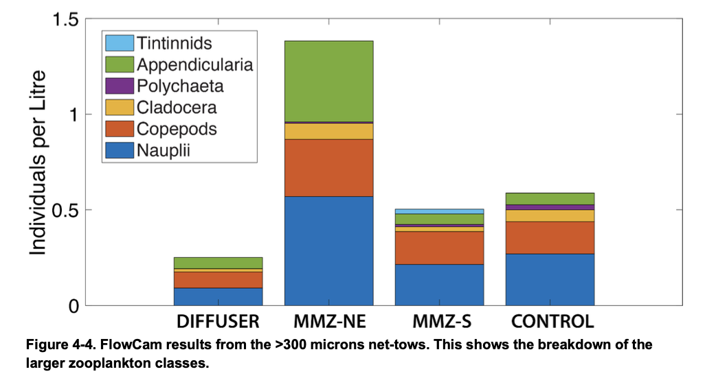
Among larger zooplankton, the primary classes observed were nauplii, copepods, and appendicularia.
There were no clear patterns across multiple sampling sites.
Due to the speed at which plankton communities can shift, Planetary recommends future sampling at other times of the year to account for seasonal differences and to better understand growth patterns.
Benthic Ecology
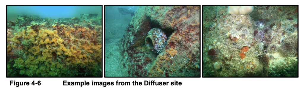
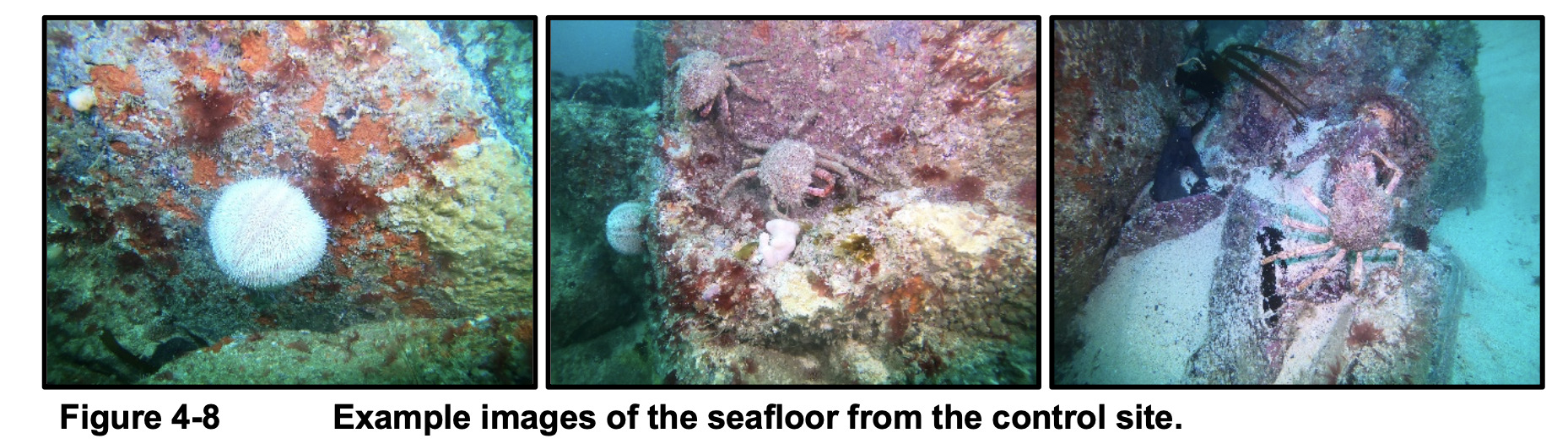
The broader ecology of each site was assessed with a dive team, who swam in a set pattern above each site to record video of the seafloor.
Based on current data, the community was characterised as a typical hard substrate benthic community for the north-eastern Atlantic with a moderate-high degree of species diversity and ecological interaction.
Species observed included sea snails, sea squirts, coralline sponges, red algae, ray-finned fishes, soft-shelled crustaceans, stony corals and anemones.
Ongoing Research
This report provides valuable baseline data that helps Planetary understand the marine ecosystem in and around St Ives Bay. It provides a reference point to identify changes and trends going forward, and also identifies areas for additional study. This report highlights the following for possible future research in the area:
- Additional plankton studies, conducted in other times of year to reveal seasonal trends
- Additional analysis of ecological data
- Validation of anomalous data, such as the high chromium levels observed in tissues of one invertebrate specimen near the diffuser site
- Continued monitoring of metals content in the ecosystem, particularly mercury in the seawater column and zinc in the sediments
- Parallel TSS and turbidity monitoring, to understand the site-specific relationship between the two
If Planetary proceeds with its proposed project in the area, data collection will continue, including before, during, and after the project’s operations. The methods used for that data collection will be informed by the results from this report, and will be made publicly available.
